Applying GIS Mapping to Environmental Law
Geographic Information Systems have become an integral part of Earthjustice's work to protect public health and the environment; GIS services are provided by our staff to support case development and litigation, advocacy and public outreach and education.

This page was published 11 years ago. Find the latest on Earthjustice’s work.
At Earthjustice, we are not waging academic battles. While our cases play out in the courts, our work is firmly rooted in the real world. Behind the motions, arguments and decisions are people, wildlife and places whose fate depends on the outcome of our litigation.
Success in our work increasingly requires that we turn to a powerful tool—Geographic Information Systems, or GIS—to understand the where, when, what and who of our issues.
Traditionally, environmental litigators pored over printed maps, reports and spreadsheets and hired experts to help make sense of the facts underlying a case. These methods can unfortunately prove to be time-consuming and expensive, and may leave us without the answers we need when we need them.
To meet these challenges, Earthjustice has developed a strong in-house GIS program. GIS employs computers, geographic data and trained staff to answer queries about the world and prepare maps and information that bring the important facts of a case into focus. This powerful tool gives us analysis and presentation capabilities on par with our frequently much larger opponents.
GIS, once the exclusive tool of a few experts, has emerged onto the center stage in many facets of modern life including government, business and social change. Many of us use GIS-based tools in everyday life—like the mapping or location-based social app on your phone—without a second thought. Thanks to 15 years of generous grants from the Esri Conservation Program, which has supplied us with state-of-the-art GIS software and training asking only that in return we put it to good use, Earthjustice has been at the forefront of applying the technology to environmental law.
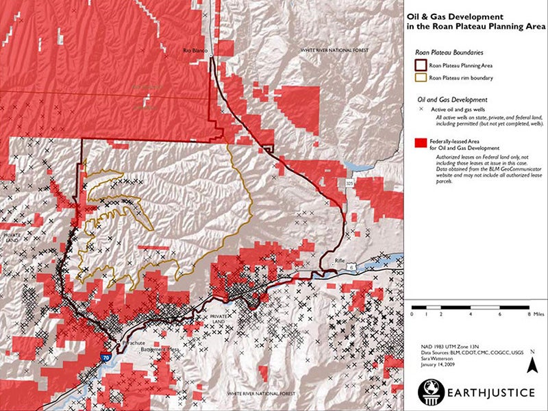
Earthjustice’s Rocky Mountain Office, starting in 1997, was the first regional office in the organization to use GIS, implementing the software to map grazing allotments and oil and gas leases in western states. Since then, GIS has become an integral part of Earthjustice’s work to protect public health and the environment; GIS services are provided by our staff to support case development and litigation, advocacy and public outreach and education.
In 2011, Earthjustice added a GIS Coordinator role to support our “GISers” and seek out opportunities to build on our successes and further integrate the technology and practices into our work. This role is especially important for us as we do not have staff who only do GIS work; rather, our support staff apply the tools as necessary to get the job done. The GIS Coordinator acts as support desk for the GIS staff and liaison with the wider GIS world, helping us keep current and effective.
As the value of GIS has been demonstrated and capable staff members have come on board, use of GIS has spread—this past year reaching twelve staff members in six regional offices and the communications department. Earthjustice has been able to apply GIS to a wide range of cases including protecting special places, combating fracking, and environmental justice:
• Our opposition to the Flaming Gorge Pipeline, carrying water from the Green River in Wyoming to the sprawling Front Range communities of Colorado, required piecing together and understanding the details of the project and its potential impacts on the river and special places along the pipeline’s route.
We turned to GIS as a tool, extracting information from the permit application and putting it under our analytical microscope. We were then able to share the information with our conservation partners through an online map and present it as formal maps in our filings before the Federal Energy Regulatory Commission.
• Earthjustice’s work on protecting communities from fracking has been a natural arena for GIS.
Maps can be powerful tools for communicating the extent of the danger, such as with the online Fraccidents map which allows concerned citizens throughout the nation to investigate how their region might be impacted.
Earthjustice staff have also prepared a map overlaying what the proposed density of natural gas wells in upstate New York would look like in Manhattan, to inform comments on New York State’s Revised Draft Supplemental Generic Environmental Impact Statement (RDSGEIS) for natural gas drilling.
The online Fraccidents map:
• Industrial power plants—also known as boilers—are dangerous sources of toxic air pollutants like mercury, lead, benzene and acid gases. Our work to protect at-risk communities from these dangerous facilities has been illustrated through an interactive online map:
In addition to generating maps for public and internal use, the GIS staff is proud of how GIS has been embraced by the attorneys as a reliable information source. We are able to use the tools to get quick and accurate answers to the myriad of questions that arise during case development and brief writing. The GIS staff often functions as reference librarians in the offices and, given the nature of our cases, the answer to a question is often geographic.
We’d like to send out a big thank you to ECP and all our supporters who have enabled our innovations with GIS and the law. The behind the scenes work, including that done by our litigation support staff with GIS, can make all the difference in our cases and to those who depend on our victories.
Earthjustice’s Rocky Mountain office protects the region’s iconic public lands, wildlife species, and precious water resources; defends Tribes and disparately impacted communities fighting to live in a healthy environment; and works to accelerate the region’s transition to 100% clean energy.